SKYLAB Provide Bluetooth Positioning System Solution for Coal Mine Tunnel Personnel

In recent years, coal mine tunnel construction personnel around the world occurred accidents often. Therefore, it is very important to track and locate the personnel working in coal mine tunnels.
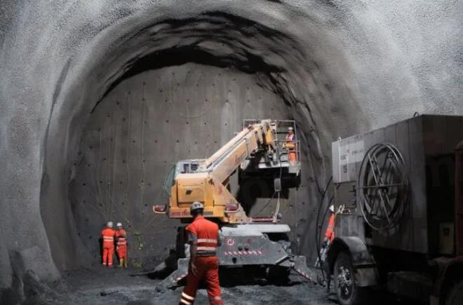
SKYLAB can provide Bluetooth positioning system solution for coal mine tunnel personnel. The positioning system is based on Bluetooth communication technology and computer technology. It can realize the data collection and positioning of mine personnel and equipment.
Coal mine tunnel personnel Bluetooth positioning system solution introduction

(1)Personnel equipment
Install Bluetooth beacons on workers' helmets or other equipment. Bind the Bluetooth beacons and miners' identity information together.
(2)Deploy Bluetooth spike base station gateway
Deploy Bluetooth dowel gateways at important locations in the mine. It can receive signals sent by Bluetooth beacons.
(3)Signal Processing
The system processes Bluetooth signals and collects information such as the time difference of signal propagation and signal strength. It can calculate the current position of the worker.
(4)Data transmission
The system transmits the positioning results to the monitoring server via Bluetooth or a wireless network. The map will display the worker's location information in real-time.
The Bluetooth positioning system can determine the miner's identity and the time of entering the mine. It can also realize mine tunnel personnel positioning, dispatching, and rescue. Bluetooth positioning system has the advantages of high positioning accuracy and low positioning cost.
Coal mine tunnel Bluetooth positioning technology principle
(1)Bluetooth signal propagation characteristics
Bluetooth signal propagation characteristics are affected by obstacles, reflections, attenuation, and other factors in the environment. Therefore, in different environments, the propagation distance and strength of the Bluetooth signal will be different.
(2)Bluetooth Signal Strength Indication RSSI
RSSI is the strength of the received Bluetooth signal. It can determine the distance and direction of the device from the Bluetooth signal source by RSSI value.
(3)Location of Bluetooth signal source
Arrange multiple Bluetooth gateways in the mine. It can determine the location of each Bluetooth beacon by collecting RSSI values from different locations.
(4)Map of the mine
Collect the location information of Bluetooth signal sources in different locations. The system can create a map of the mine to realize the positioning of people in the mine.
Coal mine tunnel personnel Bluetooth positioning system architecture
The bluetooth positioning system includes personnel and equipment positioning, monitoring, querying, data uploading and control center. The overall system architecture consists of the following parts.
Equipment data acquisition layer
(1)Bluetooth spike and Bluetooth head-mounted beacon
Each mine personnel head-mounted equipment installed Bluetooth beacon tags. Bluetooth spike gateway is mounted on the wall. Bluetooth beacon and Bluetooth gateway base station form the data acquisition system. It collects the real-time mine personnel positioning data and transmits it to the gateway in a timely manner.
(2)Gate Unit
When the mine personnel enters the gate, it can automatically locate the mine personnel through the Bluetooth positioning system. It can automatically recognize the mine personnel ID information through the Bluetooth positioning system. The system automatically uploads the mine personnel positioning information through the network.
(3)Equipment unit
The Bluetooth beacon calibrates the location information of the personnel under the mine. It forms asset identification and location identification on the server side.
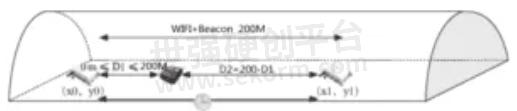
WIFI Transmission Layer
Use a high-power WIFI bridge to build data transmission from underground to the surface. It can realize wireless communication in underground mines. The wireless bandwidth rate is 300M bps and the coverage distance is 200 m. It can effectively provide underground-to-surface data transmission.
Service Layer
(1)Vector map
Vector map includes two kinds of 2D plane map and 3D three-dimensional map. It displays a comprehensive overview of the mine. The system marks the location information of mine personnel.
(2)Positioning Data
The data from the acquisition layer is processed by local Bluetooth positioning beacons. The background processing of the server gets the real-time location data of the mine personnel.
Intelligent Analysis Layer

According to the vector map data, combined with the Bluetooth positioning data. The system can realize accurate positioning of mine personnel.
Intelligent Application Layer
The data management platform includes map management, personnel management, charging pile management, whitelist management, abnormality information, and status management.
Bluetooth positioning hardware products
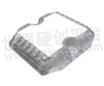
(1)Bluetooth Beacon VDB1506

VDB1506 can be installed and fixed on the safety helmet, and can also be fixed on the equipment.
◆Wireless distance: 3-30m
◆Material: Plastic ABS+PC
◆Waterproof: iP67
◆Installation method: screw fixing, 3M glue, hanging
◆Working temperature: -20℃-+70℃
◆Equipment installation: buckle
(2)Road Spikes Bluetooth Positioning Beacon VDB1612
◆Power supply: battery
◆Installation height: less than 10 meters
◆Coverage radius: 1.5 times the hanging height
◆Waterproof: iP67
◆Installation method: top, ground, wall
◆Battery life: 3 years
(3)4G/5G WIFI Bluetooth Gateway BLE5.0 VDB2607
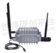
◆Installation height: according to the actual situation
◆Coverage distance: 200m
◆Rate: 300Mbps
◆Waterproof grade: IP67
Coal mine tunnel Bluetooth positioning project implementation
(1)Mine map data modeling
The modeling data is a variety of two-dimensional planes and three-dimensional planes. It is used to display locating personnel and device location information.
(2)Helmet Bluetooth beacon installation
It records personnel information, transportation equipment information, and fixed reference object information. The Bluetooth beacon cooperates with the fingerprint information of the Spike base station to determine their respective positions.
(3)Bluetooth spike base station deployment
Bluetooth spikes are used inside mines. It covers a distance greater than 20m.
(4)WIFI Bluetooth base station gateway deployment
It can realize the WIFI bridge and complete the communication layer access from underground to the ground.
The Bluetooth gateway receives the data from the Bluetooth beacon worn by the person. It is uploaded to the ground service center via WIFI.
- +1 Like
- Add to Favorites
Recommend
- What are the Functions of the Smart Construction Site Personnel Positioning System?
- 6 Bluetooth Beacons Based on nrf51822/nRF52832/nRF52810 Chip Solutions
- How To Choose The Smart Home IoT WiFi Module?
- SKYLAB and MMC developed Long-endurance UAV Power Line Patrol Automatic Solution
- SKYLAB provides UAV Petrochemical Pipeline Inspection Solution
- SKYLAB launched a GPS positioning system solution for Logistics truck GPS Positioning Tracking Application
- SKYLAB GPS positioning technology help people solve the problem of lost pets and find their pets faster,more conveniently
- SKYLAB‘s Parking Lot Bluetooth Positioning and Navigation Solution
This document is provided by Sekorm Platform for VIP exclusive service. The copyright is owned by Sekorm. Without authorization, any medias, websites or individual are not allowed to reprint. When authorizing the reprint, the link of www.sekorm.com must be indicated.
Integrated Circuits


Discrete Components


Connectors & Structural Components


Assembly UnitModules & Accessories


Power Supplies & Power Modules


Electronic Materials


Instrumentation & Test Kit


Electrical Tools & Materials


Mechatronics


Processing & Customization