SKYLAB‘s Parking Lot Bluetooth Positioning and Navigation Solution

SKYLAB's(天工测控) Bluetooth positioning and navigation solution for the parking lot is deeply integrated with the inherent parking lot management system. It provides customers with services such as parking vacant parking space navigation, recording parking spaces, reverse car search, route search, and public facilities search on smartphone terminals.

The Architecture of Parking Lot Bluetooth Positioning and Navigation System
The parking lot Bluetooth positioning and navigation system has two system architectures, including the terminal-side Bluetooth positioning and navigation system and the network-side Bluetooth positioning system.
1. Bluetooth Positioning and Navigation System on the Terminal Side (Mobile App)
Based on iBeacon Bluetooth beacons and smart terminals (such as mobile phones), the terminal performs position calculation in the SDK by scanning the surrounding Bluetooth RSSI value signals, so as to realize the offline version (no internet connection) Bluetooth positioning and navigation function.
Smart terminal system version requirements: iOS 7 or later, Android 4.3.3 or later.
Layout requirements: iBeacon spacing 6-8 meters, height 3-4 meters (the height of one floor)
Specifications: Bluetooth positioning accuracy of 1-3 meters, delay of about 2 seconds
2. Network Side Bluetooth Positioning Navigation System (WeChat H5)
Based on the iBeacon Bluetooth beacon and WeChat H5, the terminal scans the surrounding Bluetooth RSSI signal and uploads it to the Bluetooth positioning server in the background. After the server completes the position calculation, the position information is sent back to the corresponding smart terminal.
Smart terminal system version requirements: iOS 7 or later, Android 4.3.3 or later.
WeChat version: WeChat6.0 and above
Layout requirements: iBeacon spacing 6-8 meters, height 3-4 meters
Technical indicators: Bluetooth positioning accuracy of 1-3 meters, delay of about 2-3 seconds

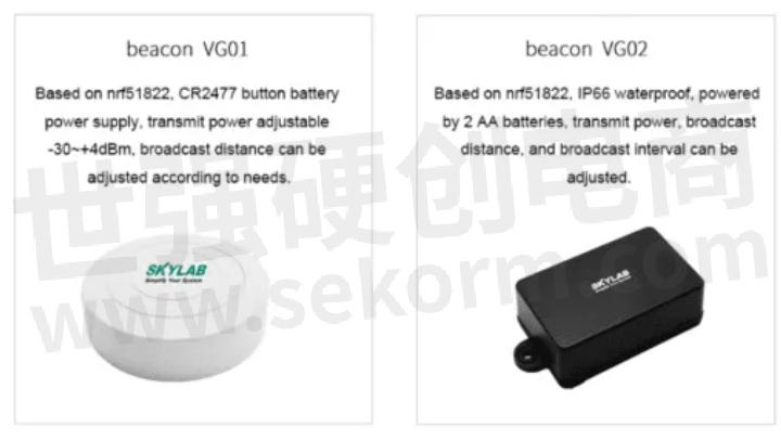
Parking Lot Bluetooth Positioning and Navigation System iBeacon Hardware
The iBeacon involved in the parking lot Bluetooth positioning and navigation system mainly includes the following two: 4.0 Bluetooth positioning base station iBeacon VG01 and outdoor Bluetooth positioning base station iBeacon VG02, as shown in the following figure.
Parking Lot Vector Map Engine and Bluetooth Positioning Navigation System

Map Bluetooth positioning and navigation system provides parking lot indoor map GIS service, including the following functions:
(1) Vector map service: support PC browser and App application
(2) POI search: support store name search and classification search
(3) Navigation service: support the route planning within the floors and the route planning between the floors
(4) Map editing background: support for adding, deleting, and modifying the shape, color, information, etc. of the map
Parking Lot Vector Map Engine System Characteristics
Parking Lot Vector Map
(1) The parking lot vector map can be displayed on the mobile terminal (android, ios) and the web terminal (web).
(2) The map can be dragged, rotated, zoomed, and the map floor can be switched.
(3) The map supports a pseudo-3D effect (shadow).

POI
(1) POI information can be displayed on the parking lot map, including POI name, POI logo, etc.
(2) POI can be clicked (click event is supported).
(3) Support POI search (fuzzy search).
(4) Support quick search of reserved type POI (toilet, service desk, elevator, etc.).
(5) Dynamic display of POI information at different zoom levels.
(6) POI information moves with the map.
(7) POI information includes configurable font, color, and line thickness.
(8) During route planning, if you need to accurately navigate to the POI entrance, you need to indicate the location of the POI entrance.
(9) POI types support shops, parking spaces, obstacles, elevators, stairs, and other types.
(10) POI data supports caching and offline packages, and version number control is added to map and POI data services.
Parking Lot Bluetooth Positioning and Navigation
(1) When positioning, the map can display the user's real-time position in the parking lot, support the positioning following function, and automatically switch floors.
(2) Support path planning in the parking lot, mark the start and endpoints, draw the planned path, and indicate the details of floor switching information when crossing floors.
(3) Support real-time positioning and navigation, and support navigation to the target entrance.
(4) Support navigation strategy selection when navigating, namely elevator priority, fastest priority, etc.
(5) The navigation supports the vertical foot algorithm, that is, the positioning point and the nearest road network are calculated as vertical foot, and the position is mapped to the road network to reduce errors.
Advantages of Parking Lot Bluetooth Positioning Navigation System

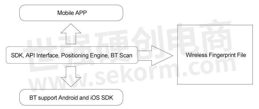
(1) Multi-user concurrent positioning: supports processing a large number of concurrent user positioning requests, using multiple buffers to relieve server pressure, Optimize access
(2) Wireless Bluetooth fingerprint collection: Bluetooth positioning fingerprint collection tool
(3) User management interface: It is convenient for third-party applications to manage Bluetooth positioning and location
(4) Bluetooth positioning calculation: the server runs the Bluetooth fingerprint positioning algorithm for positioning
(5) Bluetooth fingerprint library optimization: The Bluetooth positioning algorithm continuously optimizes and calibrates the Bluetooth fingerprint database during use to improve the Bluetooth positioning accuracy.
Parking Lot Bluetooth Positioning Navigation System
A parking lot Bluetooth positioning navigation application is a set of intelligent systems that integrate Bluetooth positioning navigation systems, parking lot vector maps, and offline parking lot management systems, which can meet users from the parking lot to the parking lot positioning navigation scenes.
The functions of the Bluetooth positioning system are as follows:

Parking Lot Information Query
The parking lot Bluetooth positioning and navigation application background is connected with the offline parking system. The parking system can record the usage of each parking space through the camera above the parking space and push it to the parking navigation application. The parking navigation application loads this information on the vector map Mark it out.

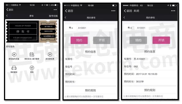
Parking Lot Reservation
Open the interface to view the number of remaining parking spaces in the parking lot. When the number is greater than 0, click "Reserve Parking Space", enter the license plate number, and click Reserve. After the reservation is successful, the relevant information such as the parking space number allocated by the reservation can be displayed. If you have reached the parking space or abandoned the reservation, you can click "Unlock" on the reservation interface.
Parking Lot Indoor Parking Guidance
For users who have reserved parking spaces, after arriving at the parking lot, open the Bluetooth positioning navigation application, enter the parking guidance interface, and select the actual entrance to the parking lot, such as "South Entrance", click OK, and the current entrance will be the starting point. The reserved parking space is the endpoint, and an optimal route is planned.
Parking Space Mark
The user enters his license plate number in his account in advance. After parking is completed, open the app and click "Remember Parking Space". The parking navigation app's backend will go to the offline parking system to retrieve the license plate location and print it on the map.
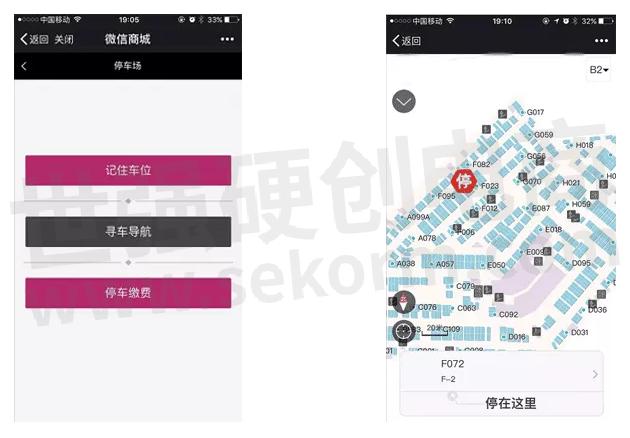
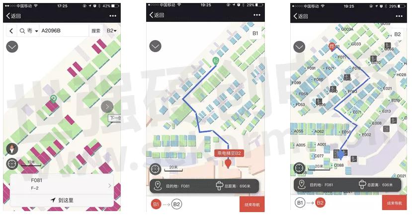
Reverse Car Search In Parking Lot
If you have remembered the parking space before, click the I want to find the car button, and automatically ends with the recorded parking space; if you have not remembered the parking space before, it will jump to the map interface, enter the license plate number and click the query button, and the desired parking space will pop up Looking for the location of the car. Then click "here", select the starting point on the map for path planning, or use the current location as the starting point for real-time positioning and navigation. Navigation can realize automatic switching between upstairs and downstairs, indoor and outdoor.
Parking Fee Payment
Click "Parking Fee Payment", enter the license plate number, and click Query to display specific details, including admission time, length of stay, and parking fee amount.
- +1 Like
- Add to Favorites
Recommend
- What are the Functions of the Smart Construction Site Personnel Positioning System?
- SKYLAB‘s Active Bluetooth Positioning System Solution with High Precision, a Large Number of Users, and High Concurrent Access
- SKYLAB and MMC developed Long-endurance UAV Power Line Patrol Automatic Solution
- SKYLAB Has Launched a Bluetooth Indoor Positioning and Navigation System Solution
- SKYLAB provides UAV Petrochemical Pipeline Inspection Solution
- SKYLAB Provides the Application of Bluetooth Beacon in Factory Personnel Location
- SKYLAB Provides IBeacon Based Bluetooth Warehouse Asset Solution
- Qorvo Visits SKYLAB Company to Explore New Developments in UWB Technology
This document is provided by Sekorm Platform for VIP exclusive service. The copyright is owned by Sekorm. Without authorization, any medias, websites or individual are not allowed to reprint. When authorizing the reprint, the link of www.sekorm.com must be indicated.
Integrated Circuits


Discrete Components


Connectors & Structural Components


Assembly UnitModules & Accessories


Power Supplies & Power Modules


Electronic Materials


Instrumentation & Test Kit


Electrical Tools & Materials


Mechatronics


Processing & Customization